THE FESTIVAL
This year the Dolores River Festival grounds will extend to the river's edge, as it grows bigger and better with all day events in Joe Rowell Park. This community and family-oriented event features numerous vendors, events in and along our beautiful river, great food and drink, and best of all, superb music by national and local acts all afternoon and into the evening.
The Festival is hosted by Greater Dolores Action, a not-for-profit local organization that generates a sustainable funding source for implementing scientific, restoration, and stewardship projects for the Dolores River. The Festival draws attention to the Dolores, the challenges it faces and the importance of preserving it. Greater Dolores Action earmarks all sponsorship donations for festival funding and for river-enhancing activities such as garbage and debris removal, habitat creation and education – keeping your generous donation in the community. Your support of the Dolores River Festival shows your commitment to the preservation of one of the West’s great and scenic rivers.
The Festival is hosted by Greater Dolores Action, a not-for-profit local organization that generates a sustainable funding source for implementing scientific, restoration, and stewardship projects for the Dolores River. The Festival draws attention to the Dolores, the challenges it faces and the importance of preserving it. Greater Dolores Action earmarks all sponsorship donations for festival funding and for river-enhancing activities such as garbage and debris removal, habitat creation and education – keeping your generous donation in the community. Your support of the Dolores River Festival shows your commitment to the preservation of one of the West’s great and scenic rivers.
MISSION
The mission of the Dolores River Festival is to design an event that bring people together to celebrate the Dolores River and the many ways it connects us to each other, the environment, and our resources.
VISION / CORE PURPOSE
To generate a sustainable funding source for implementing scientific, restoration and stewardship projects for the Dolores River.
VALUES
We help people develop a relationship with the Dolores River
We educate the public about the Dolores River
We boost the local economy
We invest in stewardship projects
We celebrate the Dolores River
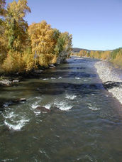
THE DOLORES RIVER
The Dolores River flows through the town of Dolores and is a tributary to the Colorado River. Its headwaters start high in the San Juan Mountains, where it flows west and then bends north below town. Flows below town through the Lower Dolores Canyon are controlled by releases from McPhee Dam. McPhee Reservoir provides water for Cortez and Dove Creek and much of the irrigated agriculture in the region. After carving the remote and scenic canyons of the Ponderosa Gorge and Slickrock Canyon, the Dolores is joined by the San Miguel River below Bed Rock. From there it continues northward to cross the state line near Gateway before flowing to the Colorado River near Moab, Utah.
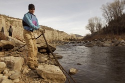
Day-trip boating and low-water tubing makes for a fun river run upstream of Dolores. A more thrilling day trip includes the legendary Stampede Hole and Ledges for kayaking and rafting near the community of Stoner. A nationally acclaimed section of Class III-IV whitewater in the lower Dolores Canyon (below McPhee Reservoir) accommodates multi-day raft trips available without permit requirements. Trips in the lower canyons reward experienced boaters with remote wilderness, archaeological treasures, and demanding rapids. These opportunities depend on flows determined largely by releases from the dam.
Day-trip boating and low-water tubing makes for a fun river run upstream of Dolores. A more thrilling day trip includes the legendary Stampede Hole and Ledges for kayaking and rafting near the community of Stoner. A nationally acclaimed section of Class III-IV whitewater in the lower Dolores Canyon (below McPhee Reservoir) accommodates multi-day raft trips available without permit requirements. Trips in the lower canyons reward experienced boaters with remote wilderness, archaeological treasures, and demanding rapids. These opportunities depend on flows determined largely by releases from the dam.
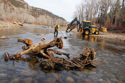
Projects: Where Your Festival Dollars Go
|
A portion of the proceeds from each year's Dolores River Festival are allocated to fund river enhancement and conservation projects.
Proceeds from the 2013 Dolores River Festival were put toward development of a river launch site near the confluence of the West Fork and Upper Dolores River. Proceeds from the 2012 Festival went to upgrades and renovations to the Children's Playground at Joe Rowell Park. Ongoing projects include:
|
   |
